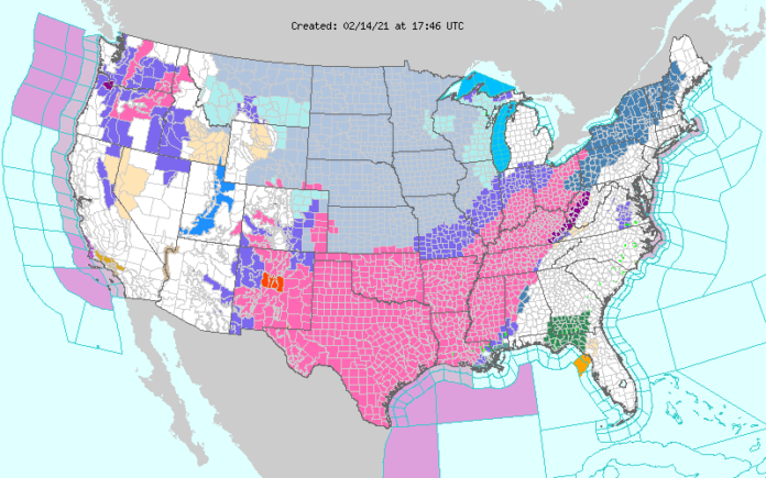
Expect delays at many airports as winter weather freezes the South and then all the way up the East Coast. The Plains will also remain frozen. The latest from the NWS:
Over 150 million Americans are currently under Winter Storm Warnings, Ice Storm Warnings, Winter Storm Watches, or Winter Weather Advisories as impactful winter weather takes shape from coast-to-coast… …Major winter storm to spread heavy snow and significant ice accumulations from the Plains to the Northeast… …Frigid Arctic air and dangerously cold wind chills to persist in the Heartland into next week… There are no shortage of winter weather hazards across the Lower 48 over the next couple days. An Arctic high pressure system supplying sub-freezing temperatures is working in tandem with an active storm track to generate a large swath of accumulating snowfall and treacherous ice accumulations. Icy conditions look to linger around the Mid-Atlantic Sunday morning but should improve throughout the day. While conditions improve in the Mid-Atlantic, conditions will deteriorate throughout the day in the southern Plains and Lower Mississippi Valley as an upper-level trough in the Southwest spawns a major winter storm over the South Central U.S. The footprint from this winter storm is so large that parts of South Texas are under Winter Storm Watches for the first time in a decade. Periods of snow, falling heavily at times, will be common from New Mexico to the Mississippi Valley today with the heaviest accumulations likely to occur in central Oklahoma and the Sacramento Mountains of New Mexico. In addition to the snow, significant ice accumulations are forecast from the Texas coast to the Tennessee Valley from Sunday afternoon into Monday. The worst ice-related impacts occur on Monday as a low pressure system gathers strength in the Gulf of Mexico. The swath of accumulating ice on Monday is impressive, stretching from south Texas to the northern Mid-Atlantic. Heavy snow on Monday will also blanket much of the Lower Mississippi, the Ohio Valley, into the Northeast. The forecast through early Tuesday morning calls for 8 to 12 inches in central Oklahoma with locally higher amounts possible. An area of 4 to 8 inches of snow looks to extend from east Texas and the Ohio Valley to the Northeast. Substantial ice accumulations of up to a half inch are possible from the Lower Mississippi Valley to the Tennessee Valley leading to dangerous travel conditions, numerous power outages, and extensive tree damage. Wintry weather is also on tap in the Northwest and Intermountain West as another Pacific storm system ushers in more Pacific moisture to these regions. Lighter accumulations are anticipated in the lower elevations, but the mountainous terrain will receive the heaviest totals. Through Monday night, the Cascades are likely to receive the most snowfall with accumulations being measured in feet in the highest elevations. Snowfall over a foot is likely from the Bitterroots of Idaho and Tetons of western Wyoming to the Wasatch and central Rockies. Winter Storm Warnings, Winter Storm Watches, and Winter Weather Advisories are located across most of these areas, along with some ongoing Avalanche Warnings that are in effect through Sunday evening. The aforementioned Arctic high pressure system looks to maintain a strong grip over the Nation’s Heartland, causing many areas east of the Rockies and west of the Appalachians to witness dangerous and record-breaking cold into the first half of the upcoming week. The north-central U.S. should once again see sub-zero high temps on Sunday, with single digit highs stretching as far south as the Texas Panhandle. Low temperatures are forecast to be range between -20 to -30 degrees across the Northern Plains and Upper Midwest. Gusty winds throughout much of the Plains and Midwest continue to foster life-threatening wind chills between -30 to -60 in the north-central CONUS. Wind Chill Advisories extend as far south as the Southern Plains and as far east as the Ohio Valley. Hundreds of daily low maximum and minimum temperatures will be broken with some February and even all-time low temperature records in jeopardy. Daily temperature anomalies in the Southern Plains both Sunday and Monday are likely to range from 25 to 40 degrees below normal.


