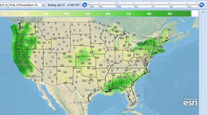
From the NWS for the week of 1/25-1/31 covering areas where Southern Airways flies:
Moderate to Heavy rain possible over the Middle Mississippi/Ohio Valleys into the Tennessee Valley through Tuesday morning. Scattered to widespread showers and thunderstorms are expected. Periods of moderate to locally heavy rainfall is expected and WPC has identified parts of the Mid-Mississippi Valley, Tennessee and Ohio Valleys and the Central Appalachians as having a Marginal Risk for excessive rainfall and flash flooding. This front will continue to track east across the Gulf states and the Southeast through the middle of the week.
Heavy precipitation likely for California into late week, followed by another event focusing along the central West Coast, from the weekend into early next week. Farther east, the deepening storm reaching the western Atlantic by early Thursday should be far enough offshore to yield a dry day along the East Coast.
The next system ejecting from the West will bring a broad area of precipitation across the eastern half of the country from the weekend into the start of next week.
Behind the deepening storm tracking through the western Atlantic, eastern U.S. temperatures will tend to be below normal from late this week into the start of the weekend. Best potential for highs 10-20F below normal will be over the Northeast around the end of the week as a compact upper low tracks overhead. The southwestern
states will also be on the cool side for most of the period with some locations up to 5-10F or so below normal for highs. Readings may reach closer to normal by early next week.


